NOAA CONFIRMS El NINO IS HERE, COULD BE THE STRONGEST IN 140 YEARS
Oceans have absorbed 23 zettajoules of heat in recent years, the equivalent of 365 million atomic bombs. Now the climate system's best-known disruptor is loading up.
by editor5 min readcomments soon
The National Oceanic and Atmospheric Administration confirmed what meteorologists have been watching for months: El Niño is officially here, and it has the potential to be one of the most powerful on record.
Ariel Cohen, a meteorologist at NOAA's Climate Prediction Center, said "That could rank among the largest El Nino events in the historical record, going back to 1950" going back to 1950. The agency estimates a 63 percent chance of a very strong El Niño developing between November and January, with conditions expected to strengthen across the Northern Hemisphere over the coming months.


THE NUMBERS ARE THERE
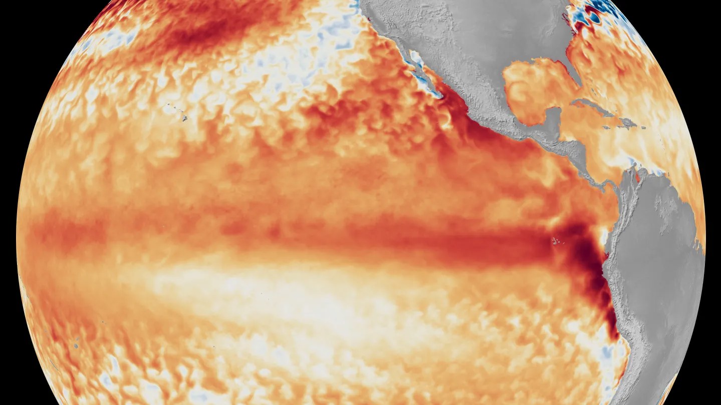
For El Niño to form officially, sea surface temperatures must climb 0.5 degrees Celsius above average in the central and eastern tropical Pacific for several months. A or "super" El Niño—NOAA does not use the latter term operationally—requires temperatures to spike at least 2 degrees above average. That threshold has been crossed only a handful of times since 1950, and the ocean has never been this warm to begin with.
The world's oceans hit a record high temperature in 2025. They have absorbed roughly 23 zettajoules of heat in recent years, which scientists at the NOAA Southwest Fisheries Science Center calculated is equivalent to 365 million atomic bombs. This is not background noise. The warming is already baked in from decades of fossil fuel burning, and El Niño is about to pour fuel on the fire.
The United Nations Secretary-General put it directly: "El Niño conditions will pour fuel on the fire of a warming world" The result, according to the World Resources Institute, could be "the result could be stronger, more persistent impacts around the world in the form of droughts, floods, cyclones, extreme heat and more" around the world.
WHAT ACTUALLY HAPPENS
During El Niño, trade winds slacken and a warm pool of water extends farther to the east than usual. The jet stream shifts, and precipitation patterns flip. That is the mechanism. What it means on the ground varies by region, but the broad strokes are well established.
In the US, the southern tier should prepare for wetter-than-average conditions, including stormier weather in the south and a wet winter along the west coast—good news for a region where some reservoirs are at all-time lows, though one wet season will not refill them. The east coast typically sees a dampened Atlantic hurricane season, while the Pacific sees the opposite: El Niño boosts hurricane activity there. The northern Rockies and southwest can expect stronger summer rains.
Globally, the pattern tilts toward drought and heat across Australia, southern Africa, and parts of India. The Amazon rainforest can experience drier conditions. Heavy rains tend to hit Peru and South America. The 2015 super El Niño—"The most recent El Niño, in 2023-24, was one of the five strongest on record and it played a role in the record global temperatures we saw in 2024" according to Celeste Saulo, the head of NOAA's National Weather Service—brought severe drought to Ethiopia, water supply shortages in Puerto Rico, and smashed records with a vicious hurricane season in the central north Pacific.
WHY THIS ONE IS DIFFERENT
Dr. Paul Roundy, a climate scientist at the State University of New York at Albany, sees "real potential for the strongest El Niño event in 140 years" if current trends hold. Dr. Andy Hazelton at the University of Miami told reporters that "All models and observations are pointing in the same direction: a very strong El Niño with significant impacts on global climate this year" The 2023-24 El Niño was one of the five strongest on record, and it helped push 2024 into the record books as the hottest year ever measured.
This matters because El Niño does not add heat to the planet—it redistributes it. But in a world where the oceans have already absorbed unprecedented thermal energy, the redistribution lands harder. A strong El Niño now could push 2027 to break global heat records again.
Ken Graham, director of NOAA's National Weather Service, reminded the public that "Every El Nino is not the same; each one is unique with its own imprint on our weather" There is significant variability even in very strong events, and the same impacts are not expected everywhere. El Niño tilts the odds, it does not guarantee outcomes.
But the odds are tilting hard.
WHAT TO WATCH FOR
The next several months will determine whether this El Niño crosses into truly historic territory. If sea surface temperatures in the tropical Pacific climb past 2.5 degrees above average—a threshold reached only once in the modern record—this event would stand alone. Even without that extreme, the combination of a supercharged El Niño on top of already record-warm oceans means the climate system is operating in territory it has never experienced before.
Dr. Joel Lisonbee, a climate scientist at the Climate Central research group, was asked whether the southern US might get a reprieve from rising temperatures. His answer: "It would have to be exceptionally wet"


That is the reality check. El Niño will reshape weather across the planet for the next nine to twelve months, and the baseline from which it operates has never been hotter.
what did you make of it?
more from science
science
IBM UNVEILS SUB 1NM CHIP WITH 100 BILLION TRANSISTORS
A new nanostack architecture doubles transistor density over the 2nm node, adding 10-15 years to the semiconductor roadmap.
science
ARXIVLABS OPENS PREPRINT SERVER FOR COLLABORATIONS
arXiv invites outside developers who share its values of openness, community, excellence, and privacy.
science
SCIENTISTS DISCOVER OLDEST WHALE GRAVEYARD
A 2023 expedition found 476 fossilized whales and at least five active whale falls in the Diamantina fracture zone, some dating back 5.3 million years.
science
CORNELL RESEARCHERS RESTORE DISCARDED EV BATTERIES TO 95%
The DEER process soaks electrodes in an electrochemical solution to dissolve the degradation layer, allowing cleaned components to go straight back into new cells without…