FEEL LIKE FLYING? GOOGLE'S FLIGHT SIM IS ON WEB
The hidden easter egg from the desktop app ports to the browser, letting anyone fly over the planet for free.
by editor5 min readcomments soon
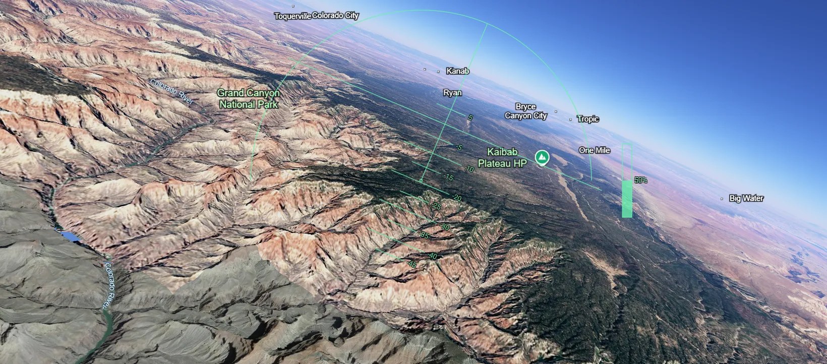
Google Earth’s flight simulator, long buried as an Easter egg in the desktop app, just landed on the web. No install, no license, no flight training required – just a browser and a moderately modern computer.
The mode appeared in the web version as a direct port from the desktop app. To find it, open Google Earth in your browser, click Explore Earth, pick a location, then navigate to Tools > Flight simulator. You are in the cockpit with a view of whatever part of the planet you selected, and you start airborne.


THE FLIGHT MODEL IS INTENTIONALLY SIMPLE
Four directions: up, down, left, and right, plus thrust control. The Up arrow nudges the nose down, the Down arrow pulls it up, Left and Right bank. The mouse controls exist but are treacherous. Within seconds of trying to change course, you can find yourself upside down and spinning. Stick with the keyboard if you want to stay oriented.
If you clip a building or hit the ground, the response is gentle: a “You crashed! Restart” message pops and you immediately take off again. No damage model, no flight dynamics beyond basic pitch and roll. This is not Microsoft Flight Simulator. It is a lightweight way to see the world from above.
The tradeoffs are real. You cannot pause or reset the flight without quitting the simulator entirely, using the back arrow in the top left, and starting again. There are no external views; you are locked to looking straight ahead from the cockpit. Google warns that "Flying at extreme speeds or over low-bandwidth connections may result in temporary loading delays". The sim works best on a strong connection and a modern Windows or macOS machine, because terrain and satellite imagery stream in as you fly.
MORE THAN A TOY
The flight simulator is the flashy part, but the underlying Google Earth platform has become genuinely powerful in its own right, and it is now fully free. Google Earth Pro, once a paid product, is free to download on Windows, macOS, Android, and Linux. No subscription, no credit card trickery.
Pro unlocks features that go far beyond the browser view. You can import and export GIS data, including ESRI Shapefiles, overlay polygons, points, and attributes onto the globe, and use historical imagery to scroll back in time and watch how places have evolved. The image library covers hundreds of cities and updates for urban areas annually or more often, though remote regions can lag for years. The images are not live: they are satellite and aerial photographs captured at different times and stitched together.
For anyone working with geospatial data, the combination of free Pro software and the web-based My Maps editor is a real workflow. You cannot edit KMZ or KML files directly in Excel, but there is a workaround: import the file into My Maps, adjust pin icons, colors, and attributes, then export the updated map back into Google Earth Pro. It is clunky but functional.
MAPS VS EARTH
Google still draws a clear line between the two products. Maps is for getting around: street navigation, turn-by-turn directions, real-time traffic. Earth is for exploring: bird’s eye views, 3D terrain, the time machine of historical imagery. The distinction matters. If you need to find the quickest route to the airport, stick with Maps. If you want to hover over the Matterhorn or see how your neighborhood has changed over a decade, Earth is the tool.
The Street View integration sits at the middle. From the planet, zoom into any supported location and drop into 360 degree Street View imagery. It is the same data that powers Maps, but the context (orbiting above then diving in) makes it feel fundamentally different.
FLIGHT SIM GATEWAY
The web flight simulator is probably not going to satisfy anyone who wants a realistic aviation experience. The controls are too basic, the scenery too laggy at high speeds, and the lack of any cockpit instrumentation or navigation aid makes it a novelty. But that may be exactly the point. It is a way to spend ten minutes flying over a place you have never seen, or over your own house from a new angle.
Google used to charge for Earth Pro, and the desktop flight sim was a nerd’s secret. Now both are free, and the sim is on the web where anyone can try it without even knowing it existed. That is a smart move: lower the barrier to the silliest, most delightful feature, and people might stick around to discover what the rest of the platform can do.


Whether you use it as a GIS workstation or a way to crash virtual planes into the Grand Canyon, Google Earth is in a strange and generous place right now. The flight simulator is just the bait. The real haul is the entire planet, searchable, time-travelable, and completely free.
what did you make of it?
more from consumer tech
consumer tech
GOOGLE ADDS YOUTUBE MUSIC, INSTACART & CANVA TO AI MODE SEARCH
Starting this week, US users can ask AI Mode to make a playlist, fill a grocery cart, or design a flyer without leaving the search…
consumer tech
THE FLAGSHIP KILLER IS DEAD: ONEPLUS QUITS THE US AND EUROPE
OnePlus is leaving North America and Europe, handing the market to parent Oppo, and pushing remaining devices onto ColorOS.
consumer tech
GOOGLE PIXEL 10 PRO DROPS TO 699, BEST DEAL YET!
A $300 discount on the 128GB model undercuts Prime Day pricing and signals a clear runway to the pixel 11 launch.
consumer tech
APPLE ONE GOES UP $2 A MONTH. THE INDIVIDUAL PLAN IS THE TELL
Family and Premier bundles climb $2 a month with nothing added, while Individual stands still. That gap is the whole story.